
Folium is one of the many open-source Python libraries that extend its capabilities. In the case of Folium, it’s a powerful visualization tool because it enables the creation of interactive maps.
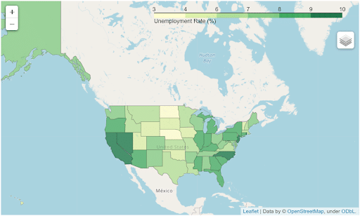
This category of maps is particularly useful because they are produced by the Leaflet JavaScript library and can be seamlessly integrated into websites. These maps are, for example, used in projects available under the Creative Commons Attribution license, such as OpenStreetMap. They are also commonly used for cartographic illustrations on platforms like Wikipedia or by media outlets like the Wall Street Journal or the Washington Post.
How does the library work?
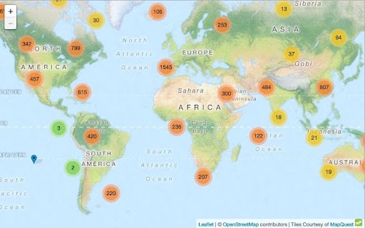
On the operational side, Folium acts as a bridge between datasets containing geographical data of various objects, manipulated with Python, and Leaflet, which generates the visual mapping. For instance, it’s possible to plot all the restaurant locations in a city on a map using a dataset containing their GPS coordinates.
The maps created this way consist of a base layer and additional layers generated by Folium that overlay on it. This makes it easy to create customized and interactive maps with Python.

What are Folium's uses?
The number and variety of objects that can be displayed using Folium are indeed extensive. Among them, you’ll find various types of maps, as well as a wide range of vector objects (circles, polygons, rectangles, pins, and more), and grids that can be used to create boundaries, among other things. Given these examples, it’s clear that the possibilities offered by this tool are numerous.
Notable examples include interactive crime rate maps created from datasets containing information on crimes and incidents in places like San Francisco.
Additionally, two learners at DataScientest used Folium in their flagship project called “City Walker,” which aims to optimize tourist routes within the city of Paris. This project compiles 10,000 points of interest classified into different categories (tourist spots, restaurants, etc.) and generates an optimal route displayed on a map using Folium.
Pour ce qui est des utilisations les plus connues, le projet OpenStreetMap a pour but de recenser des bases de données publiques et de générer des cartes interactives, et cela, par le moyen de folium. Ces cartes sont générées de manière simple ce qui en fait un outil de plus en plus populaire d’autant que ces cartes sont facilement intégrables sur un site internet.
How to master the Folium tool
Indeed, one of the well-known uses of Folium is within the OpenStreetMap project. OpenStreetMap aims to compile public databases and generate interactive maps, and Folium is a straightforward and popular tool for achieving this. The simplicity of generating these maps, coupled with their ease of integration into websites, has contributed to the growing popularity of Folium in the mapping and data visualization community.